Auckland Orienteering Champs 2019
![]() Auckland Orienteering Club invites you to join us this Labour Weekend for some high quality orienteering fun and competition, encompassing the 2019 Auckland Championships. This year the event will be contested over the three standard individual distances, Middle, Long and Sprint. The map for the Long is a new map of an area in Woodhill Forest that hasn't been orienteered on for many years. The Sprint area was originally mapped for WMOC 2017, but not used. Now we finally have a chance to use it!
Auckland Orienteering Club invites you to join us this Labour Weekend for some high quality orienteering fun and competition, encompassing the 2019 Auckland Championships. This year the event will be contested over the three standard individual distances, Middle, Long and Sprint. The map for the Long is a new map of an area in Woodhill Forest that hasn't been orienteered on for many years. The Sprint area was originally mapped for WMOC 2017, but not used. Now we finally have a chance to use it!
Bulletin: The Final Bulletin (23 Oct) is available for download as a PDF file
Results:
Middle - Results, WinSplits
Long - Results, WinSplits
Sprint - Results, Winsplits
Punching System - Air+
The Auckland Champs 2019 will use a mixed punching system for all races, with SPORTIdent Active Card (SIAC) touch-free punching available in all races in addition to normal SI punching. Competitors can choose whether they use a normal SI card or a SIAC.
Competitors using the SIAC cards do not need to pause at the control to punch, they only need to pass very near to it (within approximately 30cm). Regular SI-Cards will still work like normal when you punch the control with one. Click on the following links to download more info.
SPORTIdent Information for Athletes
SIAC cards will not be available for hire at this event; competitors who do not own one but wish to use one are encouraged to purchase one online prior to the event.
Classes
Championship grades are available for M/W10A to 20A in 2 year age groups, open M/W21E and M/W21A grades, and M/W40A upwards in 10 year age groups. Grade eligibility is determined by your age on 31 December 2018.
Instead of offering B grades and Short grades, this year we are trialing offering open non-competitive courses that anyone can enter. For example, if you normally run 40AS, you can check the estimated course lengths for each event and enter the red course that suits you best.
Children who need shadowing can enter the Open White course; however, parents or caregivers who accompany them around a course must complete their own course first
Details about course-class combinations for each event are listed below. Course lengths are approximate until closer to the event.
Middle - Saturday 26 October
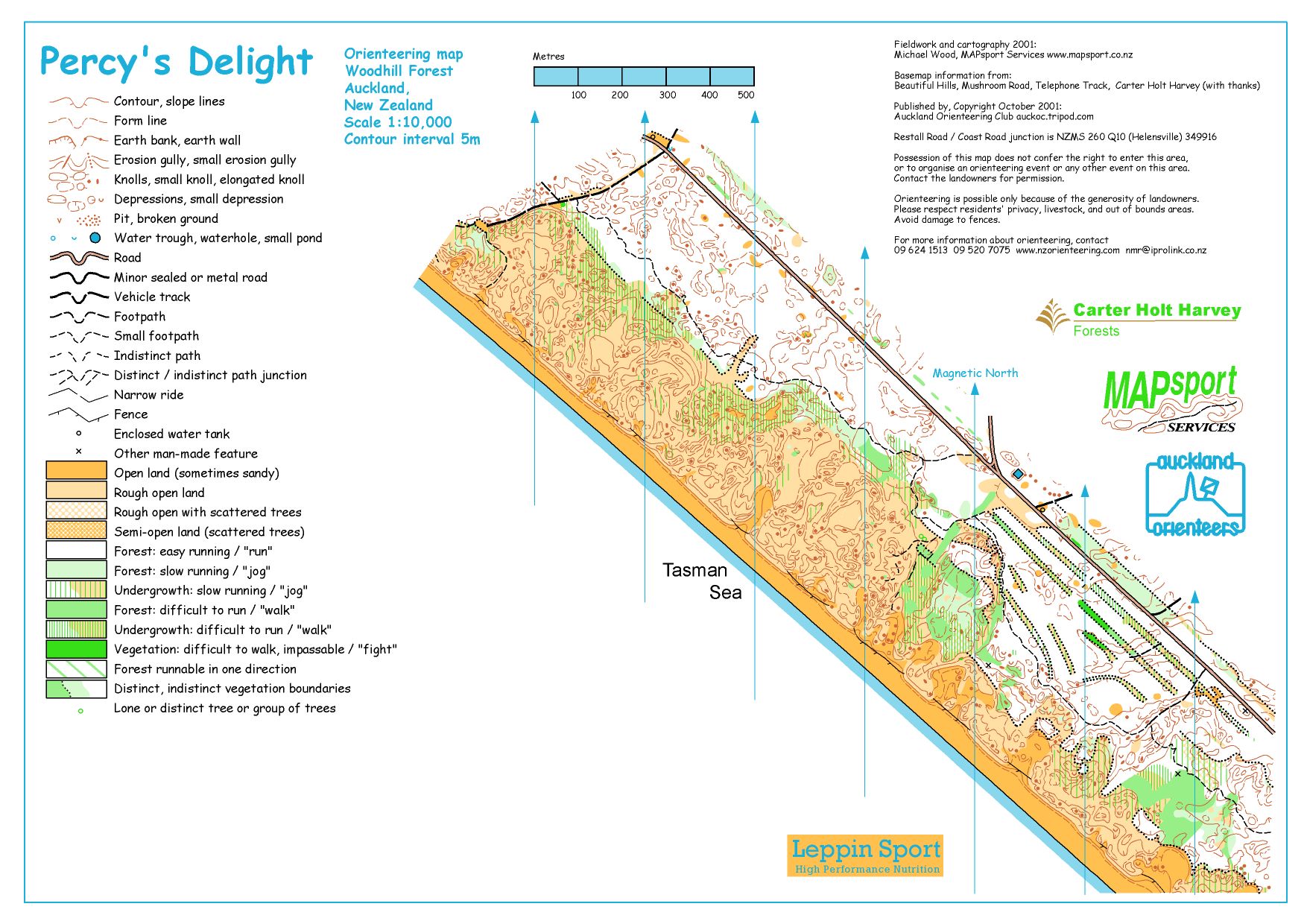
Map: Muriwai Regional Park (updated)
Mapping Specifications: ISOM 2017-2 (as published January 2019)
Planner: Alistair and Joanna Stewart
Controller: Martin Crosby
Starts: from 12pm
Old Map: Full area used as a middle in 2001 - as Percy's Delight
Expect lots of intricate detail, with terrain encompassing coastal pine forest and open dunes, varying from gentle sand dune terrain to some more rugged dunes. The mature pine forest areas are mostly fast running, with some areas of fallen branches and other small areas of recent windfalls. Open dunes have tussock, lupins, pampas and other vegetation, with other areas of bare sand. The map has some horse trails and 4WD trails in the forest, and a lot of 4WD trails in open dunes.
Preliminary Middle Course-Class information
| Course | Grades |
Middle EWT |
Middle Course Length (km) |
Grade |
| 1 | M21E Open Red1 |
35 | 4.6 | Red |
| 2 | M20A W21E Open Red2 |
35 | 4.0 | Red |
| 3 | M18A, M21A, M40A W20A Open Red3 |
30 | 3.2 | Red |
| 4 | M50A W21A, W40A Open Red4 |
30 | 3.2 | Red |
| 5 | M16A W18A Open Red5 |
30 | 2.8 | Red |
| 6 | M60A W16A, W50A Open Red6 |
30 | 2.6 | Red |
| 7 | M70A W60A Open Red7 |
25 | 1.8 | Red |
| 8 | M80A W70A Open Red8 |
25 | 1.7 | Red |
| 9 | W80A Open Red9 |
25 | 1.1 | Red |
| 10 | M14A W14A Open Orange |
25 | 2.3 | Orange |
| 11 | M12 W12 Open Yellow |
21* | 2.0 | Yellow |
| 12 | M10 W10 Open White |
21* | 1.7 | White |
* Estimated median finish times
Long - Sunday 27 October
Map: Mushroom Rd East (new)
Mapping Specifications: ISOM 2017-2 (as published January 2019)
Planner: Dave Crofts
Controller: Jeff Greenwood
Starts: from 10am
Old Map: Previously used in 1991 - as Czechoslovakia
A new map of an area not used for years. A mix of steep terrain with some gentler areas, erosion gullies, typical Woodhill sand-dune features of knolls and depressions. Mature pine trees with clear runnability over about 75% of the map. Some pampas grass and some minor areas of wind-fallen trees also. A few horse trails.
Preliminary Long Course-Class information
| Course | Grades |
Long EWT |
Long Estimated Length (km)† |
Grade |
| 1 | M21E Open Red1 |
80 | ~9.4 | Red |
| 2 | M20A W21E Open Red2 |
70 | ~7.0 | Red |
| 3 | M18A, M21A, M40A W20A Open Red3 |
60 | ~5.7 | Red |
| 4 | M50A W21A, W40A Open Red4 |
55 | ~4.5 | Red |
| 5 | M16A W18A Open Red5 |
50 | ~4.1 | Red |
| 6 | M60A W16A, W50A Open Red6 |
50 | ~3.7 | Red |
| 7 | M70A W60A Open Red7 |
50 | ~3.5 | Red |
| 8 | M80A W70A Open Red8 |
45 | ~2.7 | Red |
| 9 | W80A Open Red9 |
45 | ~2.0 | Red |
| 10 | M14A W14A Open Orange |
45 | ~3.5 | Orange |
| 11 | M12 W12 Open Yellow |
35* | ~2.6 | Yellow |
| 12 | M10 W10 Open White |
35* | ~2.4 | White |
* Estimated median finish times
† Estimated lengths provided to aid course-entry decisions, based on past events on similar terrain. Final lengths will be confirmed closer to the event.
Sprint - Monday 28 October
Map: Wynyard Quarter/Viaduct
Mapping Specifications: ISSOM 2007
Planner: Alison Comer
Controller: Guy Cory-Wright
Starts: from 10am
Originally mapped for use at WMOC 2017 but then shelved due to logistics, we have finally found an opportunity to host a Sprint in the Wynyard Quater/Viaduct Basin area. Newly updated, this map offers an interesting contrast to the campus and park maps often used for sprint orienteering in NZ. It offers an urban street network mixed with playgrounds and plazas - expect fast racing.
Sprint Course-Class information
Estimated winning time 12 - 15 minutes for all grades
| Course | Grades | Estimated Lengths† |
| 1 | M21E, M20A Open Red1 |
4.0 |
| 2 | W21E, W20A M16A, M18A Open Red2 |
3.3 |
| 3 | W16, W18 M21A, M40, M50 Open Red3 |
2.9 |
| 4 | W21A, W40, W50 M60 Open Red4 |
2.7 |
| 5 | W60 M70 Open Red5 |
2.4 |
| 6 | W70, W80 M80 Open Red6 |
1.8 |
| 7 | W14 M14 Open Orange |
2.7 |
| 8 | W12 M12 Open Yellow |
2.3 |
| 9 | W10 M10 Open White |
1.7 |
Embargoed areas
The following areas are embargoed.
Woodhill Forest
1) Northern end of Muriwai Regional Park from Telephone Track in the north to South Block Rd in the south.
2) Area bounded by Mushroom Rd to the south/west and Pulpit Rock Rd to the north/east.
Ak-Champs-Forest-embargo-area.pdf

Wynyard Quarter and Viaduct Basin
As this sprint map is in a public area, participants are allowed to enter the area but not for organised orienteering events or training.